Analyzing Digital Primary Sources
February 11, 2014
This week’s activity particularly sparks my interests since I have lived in Washington, D.C. since I was just a year old. I consider myself through and through a true and passionate Washingtonian. I did a bit of playing around on the sites before I settled on two primary sources: a map and a newspaper page, both from the year 1909. I started off with searching for a historic DC map and found one from 1909. I, then, searched the Chronicling America newspaper site focusing on that same year.
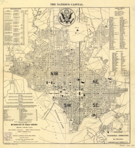
Click here to see the full sized map.
Sourcing: This map is located at the Library of Congress and is available digitally through their online database. The location, The Library Congress, is a highly credible institution run by the Federal government, so it is safe to say that this is a reliable and trustworthy primary source. It was contributed and published by a man named, Michael Ignatius Weller. After doing some research, I found an memoriam about Weller on JSTOR that described him as a man of real estate and great interest in expanding development in Washington, D.C and worked closely with Congress in doing so. JSTOR is yet another scholarly credibly source that provides reliable information.
Close “Reading”: Upon closely looking at this map, I notice a few bits of information that sets this map apart from a simple travel map. In the top left corner there is a list of the presidential inaugurations, their dates, and their locations. At the top of the page there is an official emblem of an eagle that signifies the map is of federal importance. There is information and names of the Committee that put the map together as well as a signed date.
Contexualizing: This map was devised in 1909, during a time of urban development in Washington D.C. This was a time when realtors and other city planning officials were divvying up the city into neighborhoods. The only bias I could see as a potential problem is Well’s committee drawing the map in a way that would favor them as realtors, but I doubt that since maps are mathematical and therefore very objective. It would be easy for another expert to point out inaccuracies.
Click here to see full newspaper page
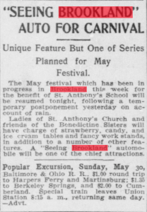
Sourcing: This is a clipping or “cropping” of an article “‘Seeing Brookland’ Auto for Carnival” in the Washington Times, dated 1909. It seems to be more so of an event listing, as the blurb below is about an event as well. There is no author.
Close Reading: The blurb discusses an automobile that will tour the neighborhood of Brookland at the “May Festival.” There is mention that the festival will benefit St. Anthony’s School and is being organized and run by the “ladies of St. Anthony’s Church” and “the Benedictine Sisters.” There will apparently be “strawberry, candy, and ice cream.”
Contexualizing: From these few sentences, a number of things can be established. This “Brookland” neighborhood could very well be dominated by Catholicism. It also suggests that the neighborhood is one worth seeing, with landmarks most likely of a Catholic nature. During a time of urban development in D.C., they could have very well been putting this neighborhood on display to draw in future residents.
Corroborating: I chose this specific article since Brookland is the neighborhood that I grew up in. While I live in NW now, I went straight for the Northeastern neighborhood of D.C. when I saw the map. When zoomed into the Brookland neighborhood (the uppermost northeastern corner of the city, on both sides of Michigan Ave.), there were not as many streets at the time, but Catholic University and the Franciscan Monastery are both landmarked on the map. These two sites are still there today. This relates directly to the article, as it discusses a fair and tour organized by Catholic institutions as well. St. Anthony’s is still in existence as well (I attended the school from Pre-K to 8th grade). Both of these sources lead to the assumption that the neighborhood of Brookland was developed and established by Catholic organizations, which I can vouch is still true, as the Basilica of the National Shrine of the Immaculate Conception, the biggest Catholic church in America, was added to the Catholic roster a couple of decades later.

